
Julia Bradbury and Ore Oduba present a guide to the British public’s favourite 100 walks, showcasing the results of a survey taken from over 8,000 British walking enthusiasts to find the nation’s favourite.
As the countdown began, we eagerly awaited to see what trail would come out on top…but the programme also served as a reminder to the sheer amount of beautiful natural spaces across the British Countryside, all inspiration for the next big adventure!
Didn’t catch it the first time? You can watch it again here.
Britain’s Favourite Walks
If you’re feeling inspired to visit some of the 100 walks featured, we’ve got a diverse selection stretching the length and breadth of the UK to help you on your way.
You’ll find details below of our selection of walking holidays from the nation’s top 100 hiking trails.
We live in a stunningly beautiful country – so let’s get out and explore it on foot!
[row class=”box-nav”][columns class=”medium-6″]
Wales
- Anglesey Coastal Path
- Llangollen Canal
- Brecon Beacons: Pen y Fan
- Offa’s Dyke Path
- Pembrokeshire Coast Path
- Gower Coast Path
Scotland
[/columns][columns class=”medium-6″]
North England
South England
[/columns][/row]
Wales

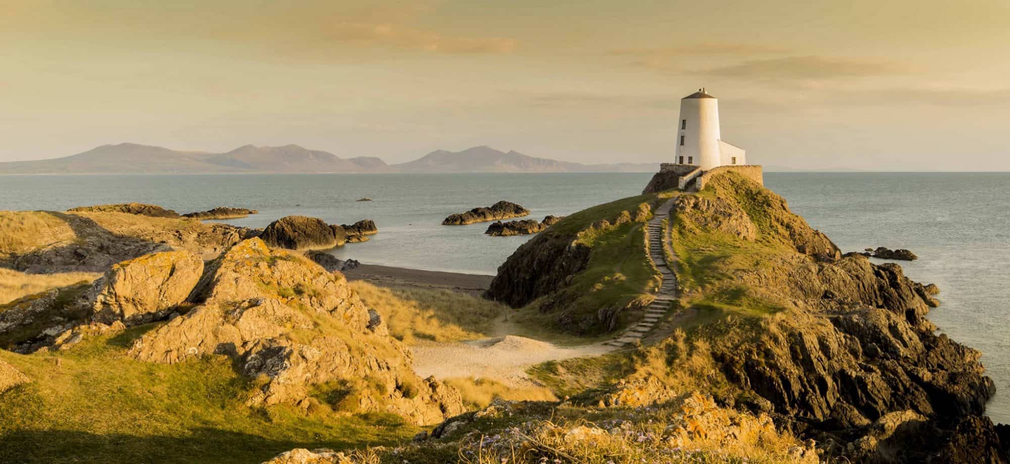
Anglesey Coastal Walk | 129.9 miles
Miles of wild and unspoilt coastline make up Wales’ largest island, with a multitude of fascinating historical and geological sites as well as nature reserves – over 95% of the island is an Area of Outstanding Natural Beauty.
Route Highlights: The atmospheric and popular retreat of Llanddwyn Island is a picturesque cove jutting out into the Irish sea. At the farthest point, you have the distinctive Tŵr Mawr (Big Tower) lighthouse. Not quite an island, Llanddwyn is easily reached by foot at all times bar exceptionally high tides.
See Full Route >
Llangollen Canal | 7.5 miles
The Llangollen Canal is part of our short break exploring the valleys and hilltops of the border between England and Wales. From the quaint borders village of Llangollen, you’ll embark on a journey that takes in ancient abbeys and the sweeping panoramas over Welsh countryside from the hilltop fort of Dinas Bran (Full Route: 33 miles).
Route Highlights: Walking the Llangollen Canal offers the opportunity to cross over the Pontcysyllte Aqueduct, designed by Thomas Telford and completed in 1805. From the top, you’ll find some fantastic views over the Vale of Llangollen. See Full Route >
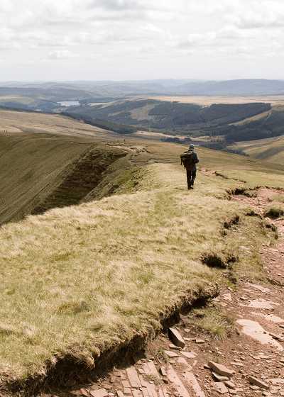
Brecon Beacons: Pen y Fan | 4.7 miles
The Brecon Beacons National Park hold some of the most awe-inspiring views found across Southern Britain, with a sky-scraping walking route that offers panoramic views over the surrounding Welsh countryside (Full Route: 100 miles).
Route Highlights: Scaling Pen y Fan, the highest peak in South Wales is a perfect experience for anyone seeking a getaway to a remote, natural environment. Aside from Pen y Fan, Llanthony Priory and Carreg Castle are both impressive historical sites that are well worth visiting on this exemplary wilderness trek. See Full Route >
Offa’s Dyke | 172.7 miles
Discover a tangible sense of walking through history with this route crossing Britain’s longest ancient monument. The trail follows traversing the Welsh border through the Wye Valley to Monmouth, past Hay-on-Wye into the Shropshire hills then Clwydian Hills that give way to Prestatyn.
Route Highlights: With so much variety in one route, it’s difficult to single out one main item! However, the popular book town of Hay-on-Wye (a true pilgrimage site for avid readers) is a unique, unpretentious town that is a popular rest day destination with our walkers. See Full Route >
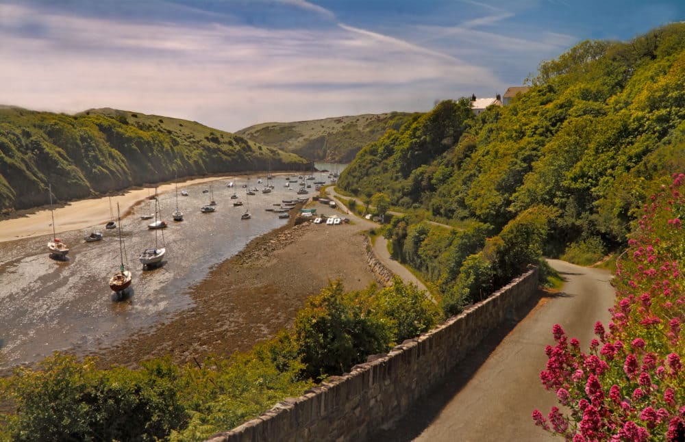
Pembrokeshire Coast Path: Solva | 4.5 miles
The Pembrokeshire Coast National Park offers some of the most pristine and wild coastline found in Britain – all open for discovery with its own dedicated National Trail. Along the way, you’ll take the clifftop paths that link the region’s villages and colourful towns to the coves and bays scattered along the shoreline (Full Route: 186 miles).
Route Highlights: Follow the trail out from Britain’s smallest city to the charming village of Solva, complete with harbour and surrounding walks over the areas unspoilt coastal scenery. See Full Route >
Gower Coast Path: Rhossili | 7.3 miles
No other beach in Britain has enjoyed more acclaim than the 3 miles of golden surf stretching over the shorelines of the Gower coast. From the coast at Rhossili there are various trails linking breath-taking natural views with the areas town, villages and historical sites (Full Route: 43 miles).
Route Highlights: Time your visit with tides and you’ll have the opportunity to visit the iconic Worms Head, a distinctive headland protruding out into the neighbouring Celtic Sea and a favourite with photographers. See Full Route >
Scotland
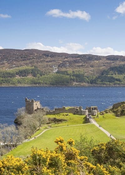
Great Glen Way | 74.1 miles
Stretching coast to coast across Scotland’s rugged highlands, this route travels from Fort William to Inverness along the Great Glen Fault. Cross the entire length of Loch Lochy, Loch Oich and the forests above Loch Ness as well as the Caledonian Canal that links them. Read an account of this section from one of our walkers.
Route Highlight: Following the high-level forest tracks from Invermoriston, you’ll have an unrivalled vantage point over the cavernous Loch Ness. See Full Route >
Fife Coastal Path | 108.7 miles
From the Firth of Forth in the south, to the Firth of Tay in the north, this trail offers an insight into the wild, natural spaces of Fife as well as the cultural highlights of St. Andrews and the thriving wildlife numbers that populate the coast of Fife.
Route Highlight: The route is an ideal way of exploring some of East Scotland’s most picturesque, quaint fishing villages, such as St. Monans, Elie and the colourful town of Culross. See Full Route >
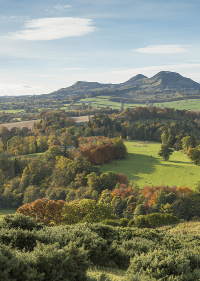
St Cuthbert’s Way (Pilgrim’s Route to Lindisfarne) | 62.1 miles
This pilgrimage route, crossing border towns through the Cheviot hills to Lindisfarne Abbey and Holy Island is a prime example of the sense of a journey that long-distance walking can inspire. Read an account of this route from one our walkers here.
Route Highlight: The causeway crossing over to the ancient abbey of Lindisfarne is the culmination of this route, but less obvious and just as memorable is the peaceful, rural scenery of the Scottish borders found along the route. See Full Route >
West Highland Way | 95.8 miles
Anyone seeking quintessential highlands scenery would be hard pressed to do better than the West Highland Way, a route through the dramatic landscape that has proved hugely popular with hikers year upon year.
Route Highlight: Loch Lomond, Ben Lomond, Rannoch Moor, Buachaille Etive Mor, Glencoe, and Glen Nevis are just some of the natural highlights of The West Highland Way. The trail is a great introduction to some of Britain’s most wild and rugged hiking, which can often prove quite taxing – although you can be certain that any steep inclines will be rewarded with fantastic views. See Full Route >
North England
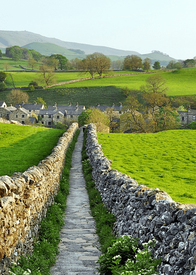
Dales Way: Grassington | 9.5 miles
The quiet, understated beauty of the rolling hills and far-reaching views of the Yorkshire Dales are the setting for this journey across from the Dales National Park to Lake Windermere in Cumbria.
Route Highlights: Grassington is an idyllic market town set against the pastoral backdrop of the Yorkshire Dales. With bustling cobble streets and a friendly local atmosphere, the town makes for a peaceful and friendly stop on the Dales Way journey. See Full Route >
Northumberland Coast Path: Alnmouth Beach and Warkworth | 6.6 miles
From the quiet fishing along the coast, to Holy Island and the genteel surroundings of Berwickj-upon-Tweed, the Norhumberland Coast PAth offers much in the way of a varied walking experience. walk along the coastline, starting in the town of Alnmouth and ending with the phenomenal Warkworth Castle. The bay has miles of golden sand and is located on the mouth of the River Aln (Full Route: 64 miles).
Route Highlights: Walking across the path from Alnmouth, Warkworth Castles cuts an impressive figure upon its mount overlooking the wide, open beaches of the Northumberland coast. Indeed, Nortumberland county has more castles than other in England, with Bamburgh and Dunstanburgh being particular highlights. See Full Route >
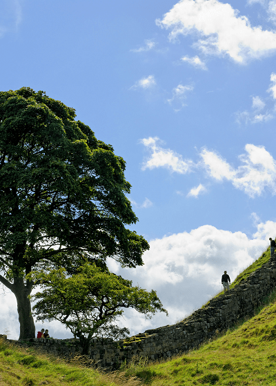
Hadrian’s Wall Path: Houseteads to Steel Rigg | 6.5 miles
A UNESCO World Heritage Site and the most ambitious structure built in Roman Britain. Forming part of the Pennine Way, this route offers some fantastic views over the crags and moors of the Northumbrian wilds.
Route Highlights: The route from Housteads Roman fort to Steel Rigg holds some truly memorable views over the Northumberland countryside, with the iconic Sycamore Gap being a particular hotspot for photo opportunities. See Full Route >
St. Oswald’s Way Dunstanburgh Castle | 7.5 miles
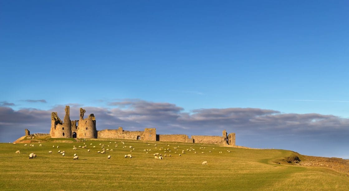
This is an ideal route for peace and tranquility, especially when you consider the fact you’re walking across the most lightly populated region in England. The trail incorporates scenic coastal routes with the lesser-known inland paths that visit sites associated with the titular saints battle to introduce Christianity to the area. (Full Route: 97 miles).
Route Highlights: Walking from the fishing village of Craster, this route crosses paths with the hulking ruins of Dunstanburgh Castle, standing upon its remote headland overlooking the North Sea. Visitors to the castle can climb its Lilburn tower, offering far-reaching views over the coast to Bamburgh castle, further down the shoreline. See Full Route >
Cleveland Way: Roseberry Topping | 6.3 miles
The Cleveland Way can be broadly described is as a walk of two halves, from the North York Moors to the fishing villages and colourful towns of the coast. Where the route drops down from the cliffs to meet the coast, the seaside town of Whitby and the old smugglers cove of Robin Hood’s Bay make up some of the more memorable points along the coastal section of the Cleveland Way (Full Route: 110 miles).
Route Highlights: This section features arguably the principal highlight of walking the inland sections across the North York Moors, culminating at the peak of Roseberry Topping. Following old dismantled quarry lines across open moorland, the sheer sense of space this walk inspires can comes as a well-needed respite to the more frenetic pace of everyday life. See Full Route >
South England
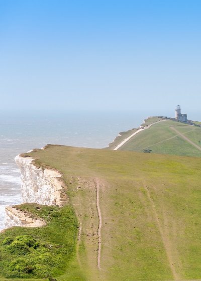
South Downs Way | 100.7 miles
A high level route across Britain’s newest National Park following the fields that stretch for miles over the chalky hills. Following the route from Winchester to Eastbourne, the sea views from the Seven Sisters cliffs are a memorable feature of an ideal introduction to long-distance walking.
Route Highlights: The Seven Sisters, Beachy Head, Devil’s Dyke, Jack and Jill Windmills, Ditchling Beacon and Chanctonbury Ring. See Full Route >
Isle of Wight: The Needles | 4.8 miles
These truly iconic group of rocks and the surrounding area offer a walk steeped in beauty and history. Take in a 19th-century fort, a cold war rocket test site and the memorial to Alfred, Lord Tennyson, the Victorian Poet Laureate (Full Route: 68 miles).
Route Highlights: A landscape beloved of the Victorian Poet Laureate, Alfred, Lord Tennyson, the route down to The Needles encompasses a 19th century fort, cold war rocket test site as well as the distinctive geological wonder of The Needles.
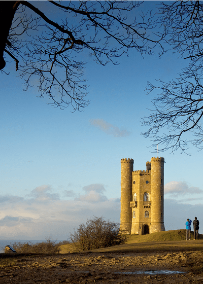
Cotswold Way: Broadway Tower | 4.2 miles
A route through the largest Area of Outsanding Natural Beauty in England and Wales, you’ll meet picturesque villages and large stretches of idyllic, rural countryside on this walk through a classic English landscape (Full Route: 102 miles ).
Route Highlights: Broadway Tower offers a spectacular vantage point over the surrounding area, with views as far-reaching as over Worcestershire to Wales. The structure was once the home of artists William Morris and Edward Burne Jones, and within the tower there’s now a café dedicated to its famous former residents. See Full Route >
The Ridgeway | 85.7 miles
The route follows the contours of the region’s chalk downs, an ancient trading route for travellers looking to scout out a potential ambush from the vantage point of The Ridgeway’s high level track. Due to this original function, you’ll find a relatively easy, peaceful walking route though meadows and wood, with far-reaching views over the Chilterns Area of Outstanding Natural Beauty from the route, as well as its culmination at the prominent hilltop of Irvinghoe Beacon.
Route Highlights: From the Avebury stones, to the White Horse at Uffington you’ll encounter many of the ancient landmarks that contribute to a real sense of walking Britain’s oldest road. See Full Route >
Peddar’s Way and Norfolk Coast Path | 83.1 miles
Windmills and wildlife scatter the cliffs, fields and sandy coves of the Norfolk Coast, on a gentle walking route through pretty towns and traditional seaside resorts. The area is renowned for its thriving wildlife population, with the reed banks, wild coast and sprawling salt marshes attracting a wide diaspora of birds and marine life.
Route Highlights: The four miles of coast at Blakeney Point offers uninterrupted views of the coastline and a seal population across the Blakeney Point National Nature Reserve. Prior to reaching Blakeney is the beautiful seaside town of Wells-next-the-Sea, comprised of stately Georgian houses and a small harbour. See Route >
South West Coast Path: St Ives to Zennor | 12.1 miles
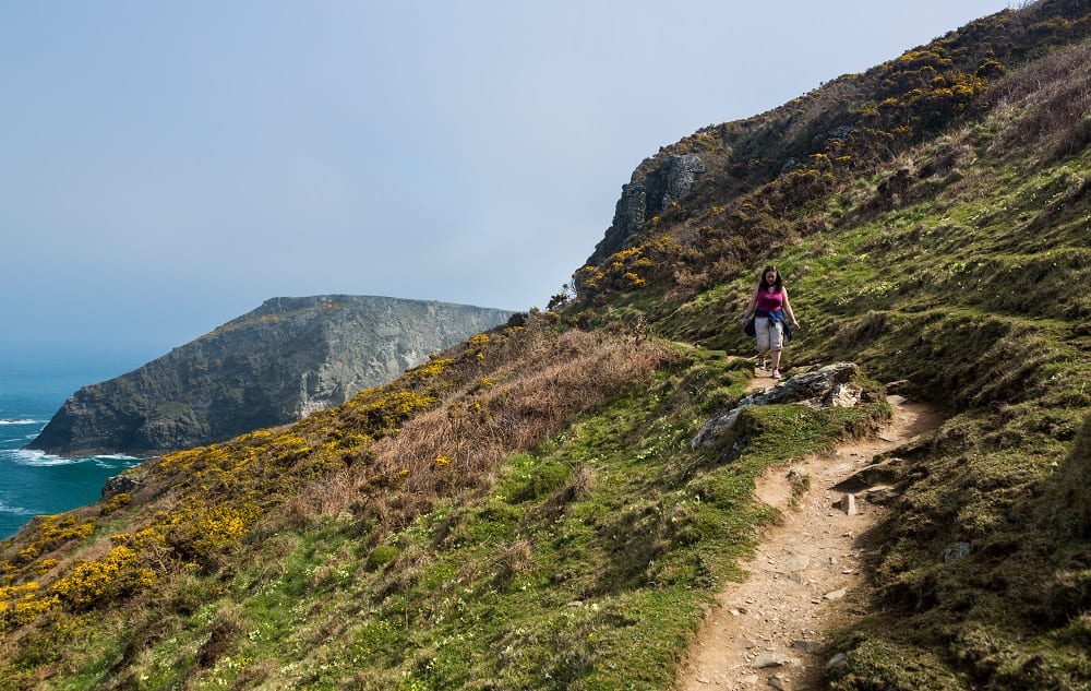
This popular walk across some of the nations most popular stretches of coast takes in many picturesque fishing towns and unspoilt stretches of coastline. Travelling on foot, you’ll find parts of this region largely unkown to the casual tourist, with a multitude of historical monuments, quaint towns and quiet bays tucked between the folds and inlets of the Cornish coast (Full Route: 62 miles).
Route Highlights: Striking out on the section between St Ives and Zennor you”ll find a rugged coastal landscape, with plenty of opportunites to take stock of your journey and admire the spectacular coastal views from the overhanging cliffs. See Route >